News
Hurricane Erin’s Path Revealed: North Carolina Prepares for Turbulent Conditions – ‘Batten Down the Hatches!’

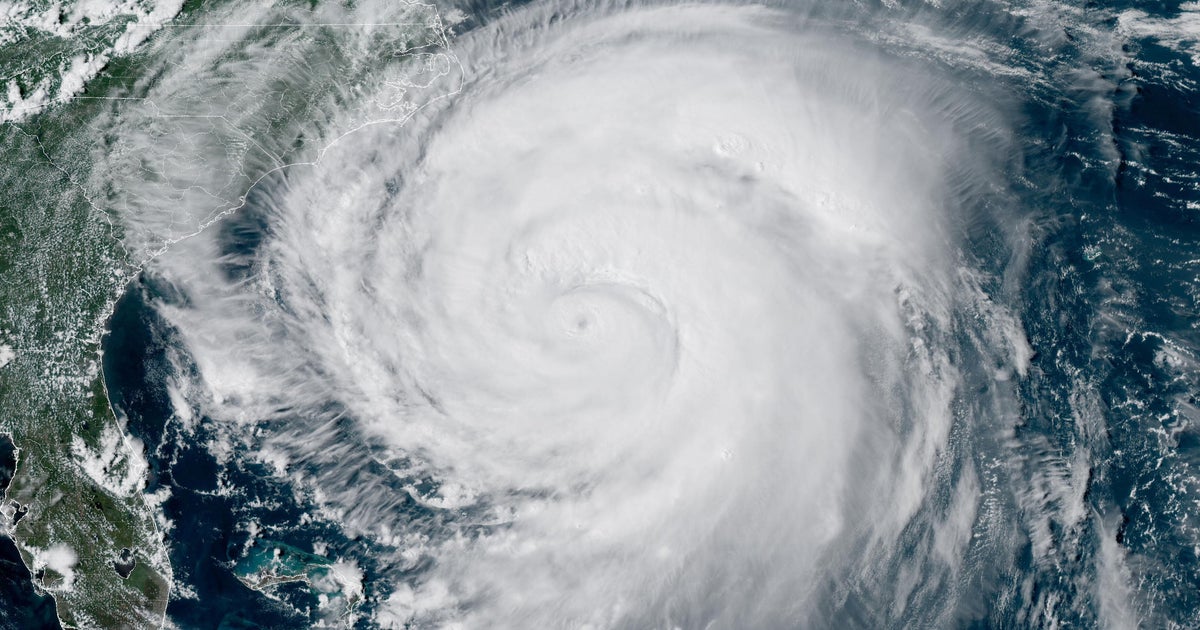
Hurricane Erin has people on the East Coast bracing for impact with its strong winds and potential for coastal flooding. The storm is currently moving along the Atlantic Ocean, creating a buzz in weather channels and among residents in its path. As of Wednesday, officials were issuing evacuation orders and cautioning folks about the risks associated with hurricanes.
The Current Status of Hurricane Erin
Erin has been classified as a Category 2 hurricane, boasting sustained winds of up to 110 mph. Early projections suggest it won’t make landfall in the U.S., but the potential for life-threatening surf and rip currents remains a significant concern. North Carolina’s Governor, Josh Stein, has taken steps to ensure residents are prepared for the incoming storm. “If you have not evacuated, make sure you batten down the hatches,” he emphasized during a briefing.
What Does Category 2 Mean?
A Category 2 hurricane features wind speeds ranging from 96 to 110 mph, which is just shy of becoming a major storm (Category 3 and above). While Erin was once a Category 5, its intensity has fluctuated, drawing attention from meteorologists and residents alike.
- Current Wind Status:
- Winds: 110 mph
- Location: About 530 miles west of Bermuda
- Movement: North at 13 mph
Tracking Hurricane Erin’s Path
Hurricane Erin is moving along a forecasted path that takes it northward over the Western Atlantic before curving towards Atlantic Canada. Despite the storm’s strength, the models currently indicate Erin should stay offshore, thanks to a high-pressure system that is expected to steer it away from the U.S. coast.
Tropical Storm Warnings are in effect from Beaufort Inlet, NC, to Chincoteague, VA.
What to Expect:
- Evacuations: Orders have already been issued for parts of the Outer Banks.
- Dangerous Conditions: Flooding and high tides are projected, with storm surges threatening to inundate vulnerable areas.
- Rip Currents: The risk of rip currents is significantly heightened, especially along the Jersey Shore and southern New York beaches.
Safety Precautions and Preparations
While residents in the Outer Banks are gearing up for potential flooding, it’s crucial to heed any alerts from local authorities. The National Oceanic and Atmospheric Administration (NOAA) recommends preparing for the unexpected.
Tips for Staying Safe:
- Stay Informed: Follow updates on weather channels and local announcements.
- Emergency Kit: Make sure you have supplies like food, water, flashlights, and batteries easily accessible.
- Evacuation Routes: Familiarize yourself with available evacuation routes and have a plan.
Rip Currents: The Hidden Dangers
Did you know that rip currents are responsible for over 80% of beach rescues? These swift channels of water can quickly pull even strong swimmers away from the shore. If you’re planning to hit the beach, keep in mind that many areas have restricted swimming or closed beaches altogether to avoid accidents.
The Effects of Hurricane Erin’s Winds
As Hurricane Erin approaches, gusts are expected to range anywhere from 25 to 50 mph. If you happen to be on the North Carolina coast Wednesday evening, you may experience quick changes in weather conditions.
Forecast Highlights:
- Wind Gusts: 25 to 50 mph
- Potential Flooding: Up to 2-4 feet of water in vulnerable areas
- Dangerous Waves: Surf conditions can produce waves of 15-20 feet.
Have a Plan
Make sure your family has an emergency plan in place. Even if the storm doesn’t directly hit your area, the resulting conditions like flooding and rough surf can pose significant risks. Keep your eyes peeled for local alerts and updates, and don’t hesitate to reach out for help if needed.
Understanding the Atlantic Hurricane Season
Hurricane Erin marks itself as the first major storm of the Atlantic season this year. The Atlantic hurricane season runs from June 1 to November 30, but activity typically peaks around September. According to the NOAA, an above-normal season is expected in 2025, with between 13 to 18 named storms anticipated.
What to Know About Storm Categories
Storms are categorized by their wind speeds, ranging from Category 1 (minimal impact) to Category 5 (catastrophic damage):
- Category 1: Winds 74-95 mph
- Category 2: Winds 96-110 mph (like Erin)
- Category 3: Winds 111-129 mph (major hurricane)
- Category 4: Winds 130-156 mph
- Category 5: Winds 157 mph or higher
If you want to dive deeper into how storms are rated, check out this NOAA resource.
Additional Resources and Information
Before heading to the coast, make sure you know the risks and prepare accordingly. The weather is fickle, and the ocean can be dangerous even when storms are far offshore. For any updates on Hurricane Erin’s path, you can always check resources from the National Hurricane Center.
By staying informed and taking proper precautions, you’ll be better prepared for whatever Hurricane Erin might bring your way. Enjoy the beach safely and remember, nature’s beauty also demands respect.
